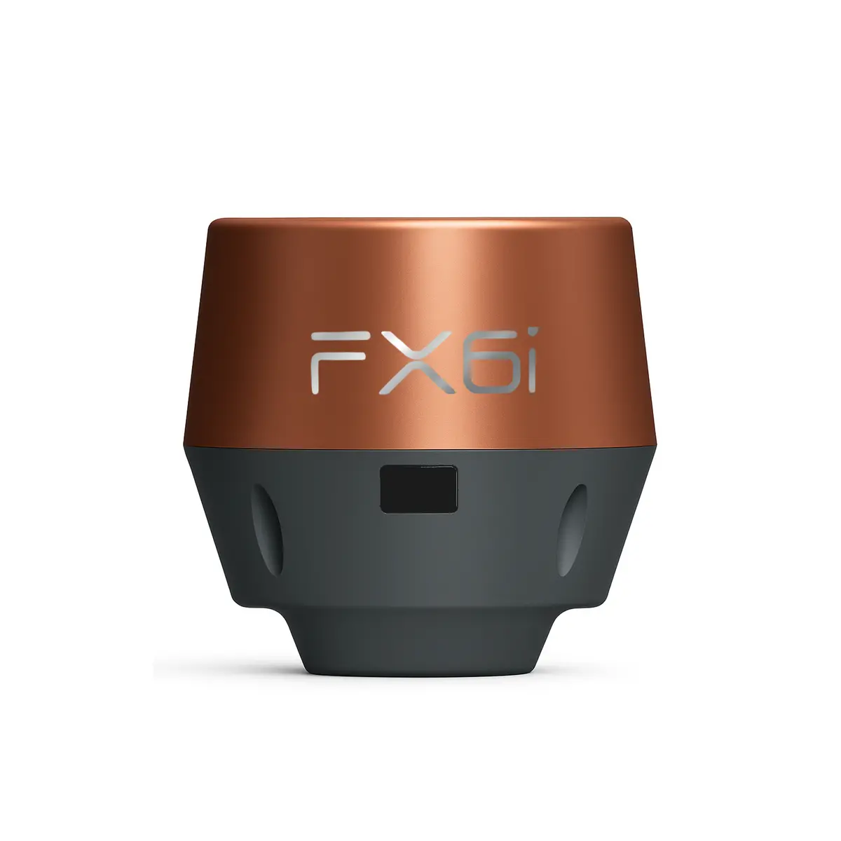
Description
Lightweight. Accurate. Rugged.
The Airace FX6i delivers professional-grade positioning accuracy with multi-constellation tracking and IMU-based tilt compensation—ideal for surveying, GIS, and construction workflows.
Key Features
- 672+ channels with support for GPS, GLONASS, BEIDOU, GALILEO, QZSS, NAVIC & SBAS
- 9-DOF IMU with tilt compensation up to 60° (no calibration needed)
- RTK & PPK accuracy down to ±5 mm
- Internal 4G, Wi-Fi & Bluetooth 5.0 for flexible communication
- 20 hours of operation (Rover mode) on a single charge
- IP67-rated—waterproof, dustproof, & built for harsh environments
- Cold start in 5 seconds—fast fix wherever you go
In the Box
- 1 Airace FX6i Receivers (Rover)
- USB-C Cable
- Radio Antenna
- Quick Start Guide
- Warranty Card
- User Manual
Quick Specs
| Size | 142 × 110 × 110 mm |
| Weight | 479 g |
| Battery | 7500 mAh, 20 hrs. usage |
| Accuracy | ±5 mm RTK with tilt |
| Protection | IP67, -20°C to +60°C |
| Memory | 32 GB internal |
The only RTK receiver you will ever need
Delivering high-precision positioning, data collection, and data processing services to a diverse range of industries.
Features:

Compact size and lightweight
Designed with lightweight and compact features, making them highly portable and easy to use without the need for bulky and cumbersome equipment.
Millimeter accurate data
Intelligent processing techniques include factors such as signal quality, atmospheric interference, and satellite geometry to provide highly accurate and reliable position information
Anyone on the team can use RTK
The interface is designed to be intuitive and easy to navigate with clear and concise instructions. Anyone can use our GNSS receiver without any training.

Specifications:
Mechanical:
- DIMENSIONS: 142 X 110 X 110 mm
- WEIGHT: 479 g
- OPERATING TEMP: -20 to +60 °C
- STORAGE TEMP: -40 to +85 °C
- WATER / DUST PROOF: IP67 rated
- HUMIDITY: 5% – 95% non condensing
- SCREEN: OLED Screen for real time status visibility
Electrical:
- AUTONOMY: Rover Mode: upto 20 hrs | Base Mode: upto 12 hrs
- BATTERY: Li-Ion 7500 mAh, 3.7 V
- CHARGING: USB Type-C, 5V 2A
- CHARGING TIME: Typically 4 hours
Positioning
- STATIC (PHASE) LONG OBSERVATION : 3 mm + 0.5 ppm (horizontal)
6 mm + 0.5 ppm (vertical) - RAPID STATIC: 3 mm + 0.5 ppm (horizontal)
5 mm + 0.5 ppm (vertical) - PPK: 7 mm + 1 ppm (horizontal)
14 mm + 1 ppm (vertical) - CODE BASED DIFFERENTIAL GNSS POSITIONING
0.25 m + 1 ppm RMS (horizontal)
0.40 mm + 1 ppm RMS (vertical)
SBAS: typically <2m 3DRMS
- RTK (NETWORK & RADIO): 8 mm + 1 ppm (horizontal)
10 mm + 1 ppm (vertical)
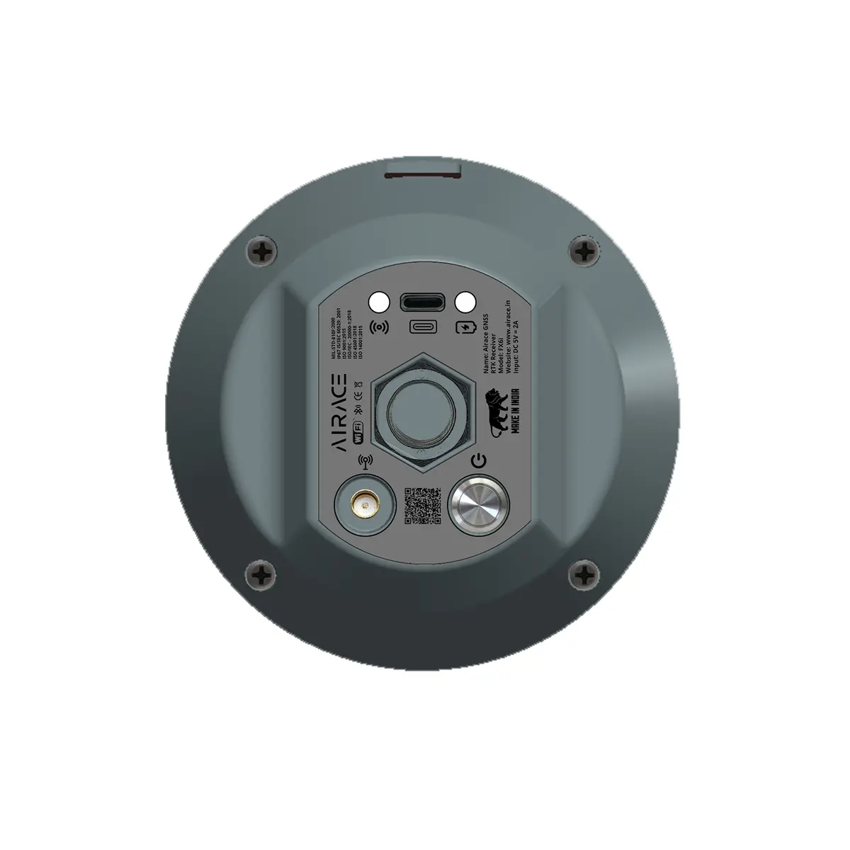
Connectivity
- BLUETOOTH: Bluetooth 5.0 for wireless connectivity
- WIFI: Built-in Wi-Fi 2.4G, 802.11 b/g/n for network communication & data transfer
- NETWORK COMMUNICATION: Internal 4G TDD-LTE/ FDD-LTE/ WCDMA/ GPRS/ GSM (900MHz & 1800 MHz), WCDMA, 2100MHZ/900MHZ, LTE BAND 1,3,7,8,20
- TYPE C: USB Type C port for charging & data transfer
- NMEA OUTPUT: NMEA-0183 output for compatibility with external devices over Bluetooth
- OPERATING SYSTEM: FreeRTOS
- STARTUP TIME: 5 Seconds
Data
- CSV: Comma Separated Values
- PDF: Portable Document Format
- KML: Keyhole Markup Language
- DXF: Drawing Exchange Format
- SHP: ESRI Shapefile
GNSS
- SIGNAL TRACKING: GPS, GLONASS, BeiDou, Galileo, SBAS, QZSS, NAVIC
- SIGNAL RECEIVED: GPS L1/L2/L5, GLONASS L1/L2/L3, GALILEO E1/E5a/E5b/E6, BDS B1/B2/B3, QZSS L1/L2/L5/L6, SBAS L1/L5, IRNSS L5 L-Band
- NUMBER OF CHANNELS: 672+ channels
- UPDATE RATE: upto 20 Hz
- MEMORY: 32 GB Internal Memory
- RTK BASELINE: upto 70 Km
- PPK BASELINE: upto 70 Km
- PPK POSITIONING: Any Point on Earth
- IMU POSITIONING: 9 DOF, Calibration Free 60° to 120° tilt compensation in RTK Mode

Built for the Field.
Compact, rugged, and weatherproof (IP67), FX6i is made to handle the real world—from dusty construction sites to humid farmlands—all while staying light in your backpack.

Plug. Connect. Survey.
From Bluetooth pairing to point collection, Airace FX6i streamlines your workflow with a clean, user-friendly interface. Setup is smooth and quick, so your team can focus on results, not the process.

Accuracy That Inspires Confidence.
Engineered for precision, FX6i delivers millimeter-level data using intelligent GNSS signal processing. Perform confidently even in tough environments with reliable results every time.
Explore more from our collection.

Reviews
There are no reviews yet.